To Understand Food Deserts, We Need To Understand Food Systems
It’s important to understand where people lack access to healthy food, but even more important to understand how resources could be rearranged and reallocated to close those gaps.
It’s not enough to just map out areas where access to healthy food is lacking; to really become actionable, that information needs to be surrounded by data that covers all aspects of a food system. [Photo: jwilkinson/iStock]
Mapping food deserts–areas where fresh, healthy food is hard to come by—is nothing new. In 2011, the U.S. Department of Agriculture released its Food Desert Locator, an interactive map of the entire country.
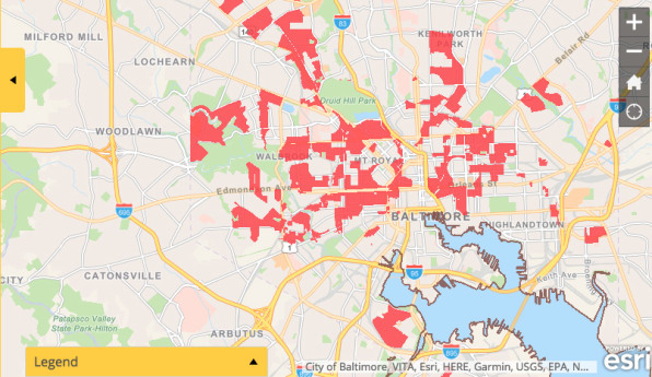
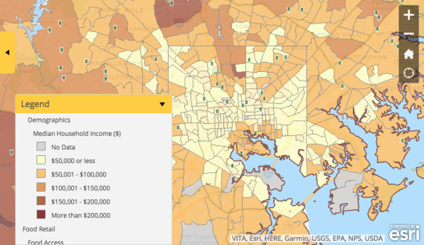
But food desert maps, in and of themselves, don’t point to a solution. The Maryland Food System Map (MFSM), launched in 2012 and comprehensively revamped this year, does. The MFSM plots out food deserts, but it also details the state’s entire food system. You can see the distance between a local farm and a food desert; you can see that a supermarket and a farmer’s market are clustered within a stone’s throw of each other, while the next neighborhood over lacks crucial food resources.

The MFSM is run through Johns Hopkins University’s Center for a Livable Future, whose mission “is to promote research and to develop and communicate information about the relationships between diet, food production, environment, and public health,” says Caitlin Fisher, program officer at CLF who oversees the MFSM. From the perspective of the CLF, it’s not enough to just map out areas where access to healthy food is lacking; to really become actionable, that information needs to be surrounded by data that covers all aspects of the state’s food system to understand what gaps in access look like, how they come about, and how to close them.
The map launched in 2012 with 30 data indicators, focused mainly on retail outlets: locations of supermarkets, convenience stores, and small local shops. Over the years, CLF continued to build out the map to include 175 data indicators, adding layers for agriculture (small farms, livestock operations, prime farmland), demographics (income, employment), health (mortality, diabetes, and obesity rates), and environmental indicators (air and water quality, biodiversity, and designated environmental cleanup areas).

Anyone can access the map and download datasets, which, after CLF received a research grant from Amazon Web Services this year, are stored and maintained in the cloud for more streamlined access, Fisher says. However, she adds, the map has had the greatest impact as a policy and advocacy tool, and various nonprofits and food policy councils across the state have used it to proactively address food access gaps.
In 2016, for example, Montgomery County kicked off the process of developing a food security plan for the region, with a goal of reducing the current number of more than 77,780 food-insecure individuals by 22% by 2020, and eventually working toward a county in which all people have access to safe, healthy food at all times. “The Montgomery County Food Policy Council took some of the data from the mapping project on demographics, food pantry and store locations, health, and food security, and put it to use,” Fisher says. “One of the things we try to stress with this mapping application is that while it’s great to have this publicly available data, it’s up to the people accessing it to take it and ground truth it.”
That might mean a city agency encouraging a farmers market to move into a food desert, or a food retail chain doing the same. It might mean food retailers or food banks using the map to identify nearby farmers, and developing an arrangement where they source directly from them to ensure a constant supply of fresh, seasonal produce. In Baltimore specifically, CLF worked with the city’s Food Policy Initiative to map out food access across the city, and tackle the gaps from an urban-planning perspective. One result of that effort, which began in 2015, was the Baltimore City Orchard Project–a nonprofit that plants clusters of fruit trees in parks and underused spaces around the city–targeting their new projects specifically to populate food deserts and create a new fresh produce resource in the neighborhoods.
The MFSM has inspired Maine to undertake a similar mapping project across the whole state, and most recently, CLF has been working with the city of Austin to develop a local food system and access map like the one Baltimore is currently working off; the Department of Health in Philadelphia has also reached out to CLF with interest in doing a similar analysis. “It’s important to be looking at this issue as a fuller picture,” Fisher says, “and recognize that there are multiple solutions across sectors, across systems, and across levels that need to be integrated.”

No comments:
Post a Comment